
|Articles|September 1, 2016
- Special Issues-09-01-2016
- Volume 31
- Issue 9
Field-Portable VNIR Spectrometry: Applications for Mars Rover Operational Strategies Testing at Terrestrial Analog Sites
Visible-near infrared (VNIR) spectroscopy provides a wealth of compositional information, and is a valuable tool in planetary exploration. The 2016 GeoHeuristic Operational Strategies Testing (GHOST) program is a terrestrial analog rover simulation designed to refine Mars Rover operational strategies. The GHOST program utilized a TerraSpec Halo handheld VNIR spectrometer to simulate the function of the Mars Science Laboratory (MSL) ChemCam and Mars 2020 rover SuperCam. Commercially available instrumentation is employed to eliminate engineering, communication, and mission-specific specifications, and allow the GHOST team to focus solely on investigative protocols. The portable spectrometer allowed for rapid data acquisition of in-situ outcrops, similar to those data gathered by Mars rovers, and allowed the instrument operator to rapidly traverse the field site, maximizing the number of data points gathered for the science teams.
Advertisement
Visible-near infrared (VNIR) spectroscopy provides a wealth of compositional information and is a valuable tool in planetary exploration. The 2016 GeoHeuristic Operational Strategies Testing (GHOST) program is a terrestrial analog rover simulation designed to refine Mars Rover operational strategies. The GHOST program used a handheld VNIR spectrometer to simulate the function of the Mars Science Laboratory (MSL) ChemCam and Mars 2020 rover SuperCam. Commercially available instrumentation was used to eliminate engineering, communication, and mission-specific specifications, and allow the GHOST team to focus solely on investigative protocols. The portable spectrometer allowed for rapid data acquisition of in situ outcrops, similar to the data gathered by Mars rovers, and allowed the instrument operator to rapidly traverse the field site, maximizing the number of data points gathered for the science teams.
The GeoHeuristic Operational Strategies Testing (GHOST) project was developed to test various rover science operational protocols, and determine a “best practice” site investigation method for future rover missions (1). Rather than using mechanical rovers or replica Mars instrumentation (for example, see reference 2), the GHOST program uses human “rovers” and off-the-shelf field-portable instruments to isolate the variables of the scientific decision-making process. This approach eliminates the need for mission-specific instrumentation, communication and data relays, and complex engineering requirements, while still providing the same basic information, such as mineralogy. The primary objective of the 2016 GHOST field season was to assess the efficiency and effectiveness of the traditional linear approach-a single path with no backtracking, commonly used by rover investigations-versus a walkabout methodology, where the site is initially reconnoitered remotely and this information is used to choose sites for more detailed interrogation. Although it is potentially longer, the walkabout method allows the science team to conduct an initial assessment of the field site to determine the best possible areas of interest for further in-depth analysis.
Field operations focused on a 2.6-km2 (1 mi2) region of the Utah desert, roughly 20 km southeast of Green River, Utah. The region primarily consists of sandstone, mudstone, and limestone-representing a groundwater-fed lake system (3) that is similar to formation models proposed for the Mawrth Vallis region of Mars (4–8). Limestone capping units with preserved microbial mat structures are also present at the site (3). The location was chosen because of the presence of similar sedimentary deposits on Mars (4–8), as well as the preserved biological structures-the identification of which will be a primary goal of future Mars missions (see reference 9 for more information). Before the field campaign, the GHOST team used Mars analog remotely sensed datasets (Figure 1) to plan the rover traverse path and preliminary waypoints for in situ investigation. Visible images were analogous to those collected by the Mars Reconnaissance Orbiter (MRO) Context Camera (CTX) and High Resolution Imaging Science Experiment (HiRISE) cameras, with resolutions of 6 m/pixel and 30 cm/pixel, respectively (10,11). Visible-near infrared (VNIR) spectrometry data were analogous to MRO’s Compact Reconnaissance Imaging Spectrometer for Mars (CRISM) instrument, with a resolution of 18 m/pixel (12).
Figure 1: Mars analog remotely sensed data used for mission planning. Left: CTX analog visible imagery (6 m/pixel). Right: CRISM analog VNIR (18 m/pixel) from the Landsat 7 Thematic Mapper, overlain on HiRISE analog visible imagery (30 cm/pixel). CTX and HiRISE analog data were created using orthorectified panchromatic images from the Utah Geologic Survey.
Instrumentation
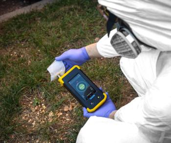
The VNIR instrument used for the rover analog investigation was the TerraSpec Halo field-portable VNIR spectrometer from ASD/PANalytical. The spectrometer is a contact probe that measures reflected light from 0.35 mm to 2.5 mm with a 6 nm/band spectral resolution (13). It was deployed in this study as a field-portable stand-in for the Mars Science Laboratory (MSL) ChemCam and Mars 2020 SuperCam instruments. Both rover-based VNIR spectrometers sample select windows were within the 0.35 mm to 2.5 mm range of terrestrial field VNIR spectrometers (14–16). The primary difference between the imaging systems used on Mars and our experimental simulation is ChemCam and SuperCam’s ability to sample a complete scene via the passive sampling function (14,16) (Figure 2a), while the field-portable spectrometer operates solely as a contact probe-sampling an area with a diameter of 1 cm (Figure 2b). The MSL ChemCam instrument is also capable of point analysis through its laser-induced breakdown spectroscopy (LIBS) function. Although this method also returns compositional data, it operates by vaporizing the sample and sampling the emitted light as the excited electrons return to their ground state, rather than by measuring the reflected light in the VNIR spectral window (14).
Figure 2: (a) A ChemCam Remote Micro Imager (RMI) scene (CR0_439663426PRC_F0240312CCAM02475L1; NASA/JPL-Caltech/LANL) superimposed on a MastCam image (0475MR0018870000302888E02_DXXX; NASA/JPL-Caltech/MSSS) of the base of Mount Sharp, Gale Crater, acquired on sol 475 of the Curiosity Rover mission. VNIR reflectance of the area within the circle was sampled via ChemCam’s passive function. (b) Sampling site with the field-portable VNIR spectrometer. Sampled area, “Quinn,” is within the circle. Inset: The field-portable spectrometer in action.
Methods
Orbital data were used to develop hypotheses about the field site and plan notional traverses for both the walkabout and linear science teams. The two science operations teams (linear and walkabout) were given three days to remotely investigate the field site by sending their respective human “rovers” and human-operated instruments out to gather data, while the science teams remained at mission control-the base camp where the science teams were sequestered-unable to see the field site in person. A third team of geologists also surveyed the field site as a control. The one field spectrometer deployed for this study gathered data for both rover science teams and the team of geologists simultaneously. The spectrometer was calibrated and white-referenced before each sample was gathered, and the resulting spectra were checked before leaving the outcrop to ensure that high data quality was maintained throughout the investigation. Upon returning to mission control, data were downlinked and processed using ITT Exelis’ Environment for Visualizing Images (ENVI) software. Field spectra were matched to reference spectra from commonly used spectral libraries such as the United States Geological Survey (USGS) spectral library (17) and the CRISM Analysis Toolkit (CAT) (18,19).
Results
A total of 43 spectra were gathered over the course of the various science team investigations of the field site. Each team worked independently of the others, and collected spectra where they felt it was necessary or would aid them in their scientific interpretations. A total of 21 spectra were gathered for the linear science team, 15 for the walkabout science team, five for the ground-truthing team of geologists, and two additional spectra were shared between all groups. All samples were collected in situ, with roughly half of the spectra gathered on the first day, and the remainder on days 2 and 3. The instrument operator covered between 10.5 and 13.7 km each day by executing multiple deployments into the field and the subsequent data return to mission control. In locations with highly varied weathering patterns, the team simulated the scene sampling ability of ChemCam and SuperCam by gathering multiple spectra within one outcrop--with a focus on color and texture variations (Figure 3). Identified mineralogy included montmorillonite, kaolinite, illite, nontronite, general smectite, calcite, dolomite, gypsum, amorphous silica, hematite, Fe3+, Fe2+, and Mn-oxide (desert varnish) (Figure 4). VNIR mineralogy was confirmed in locations where the science teams gathered additional chemical data via the portable X-ray diffraction (XRD) instrument that was also operated as part of this analog study.
Figure 3: A heavily weathered limestone outcrop, with spatially varied weathering products. Samples A, B, and C all contain montmorillonite, amorphous silica, and calcite. Spectral variations at the short wavelengths likely correspond to Fe, Mg, and Mn weathering products, such as hematite, desert varnish, and Mg-bearing smectites.
Discussion
The field-portable spectrometer was a valuable addition to this terrestrial analog study of Mars rover science team methods. The instrument’s portability allowed the operator to rapidly traverse the field site for data collection and return to mission control. This swift turnaround gave the science teams the data they required to plan their next investigative steps, with minimal wait time. Additionally, the instrument operator was able to scale large scree slopes and reach outcrops that a rover may not be able to physically reach, but could still interrogate with remote instruments. Where mineralogical variations occurred across an outcrop, multiple spectra were gathered in the same way that the current MSL team collects multiple ChemCam targets to sample compositional heterogeneity.
Although the science teams had access to remotely sensed VNIR data, the field-portable VNIR provided a wealth of detail that could not be gleaned from the much coarser orbital data (Figure 4). Orbital VNIR shows carbonates (general carbonate and dolomite), various smectites, Fe2+, Fe3+, and hydrated silica throughout the region. However, in situ sampling suggested a more diverse mineralogy with a wide variety of phyllosilicates, Fe- and Mn-oxides, and sulfates. Additionally, hydrated silica, various smectites, and calcite were shown to be ubiquitous throughout the field area rather than confined to specific units, as suggested by the orbital data. These mineralogical variations are significant because such geochemical differences contain clues regarding whether a geologic environment was habitable or capable of preserving evidence of prior life. Without the in situ VNIR data, the science teams would have missed critical information for their mission and interpretations.
Figure 4: In situ mineral identifications compared to the remotely sensed data available to the science teams before the mission. In situ data provide far greater detail and reveal more diverse mineralogy than what can be gathered from orbit.
Although data analysis requires a familiarity with VNIR spectra and processing software, the instrument’s ease of use would allow another minimally trained team member to gather spectra while the VNIR expert remained at mission control to process returned samples. One instrument operator gathering and processing data for three separate science teams simultaneously often led to a lag between each science team’s deployment of the instrument and getting the mineralogical results. A two-person approach-with one instrument operator collecting spectra in the field and a separate VNIR expert processing returned data at mission control-would result in a faster sample turnaround time, and would allow the science teams to make more efficient use of their limited time at the field site.
Conclusion
The 2016 GHOST rover science teams were able to gather and use the desired data for their investigation of the field site, and continued to refine their operational methods for future Mars rover exploration with minimal equipment delays. Additionally, the differences between the terrestrial field instrument and the rover instrumentation did not negatively affect the science team operations or the investigation of operational methods. Although the field-portable spectrometer is not an exact replica of the MSL ChemCam or the Mars 2020 SuperCam, the successful geologic investigation of the field site conducted by the science teams suggests the field-portable VNIR instrument is a suitable stand-in for rover-mounted VNIR in this terrestrial analog study.
References
- R.A. Yingst, B.A. Cohen, B. Hynek, M.E. Schmidt, C. Schrader, and A. Rodriguez, Acta Astronaut.99, 24–36 10.1016/j.actaastro.2014.01.019 (2014).
- D. Eppler et al., Acta Astronaut.90, 224–241 10.1016/j.actaastro.2012.03.009 (2013).
- S. Potter-McIntyre, “Diagenetic Alteration and Concretion Formation in the Jurassic Brushy Basin Member of the Morrison Formation, Colorado Plateau, USA: An Analog Study for the Yellowknife Bay Formation at Gale Crater, Mars,” presented at the Geological Society of America Annual Meeting, Vancouver, British Columbia, Canada, 2014.
- J.-P. Bibring et al., Science312, 400–404, 10.1126/science.1122659 (2006).
- J.L. Bishop et al., Science321(August), 830–834 (2008).
- W.H. Farrand, T.D. Glotch, J.W. Rice, J.A. Hurowitz, and G.A. Swayze, Icarus 204(2), 478–488, 10.1016/j.icarus.2009.07.014 (2009).
- B.L. Ehlmann et al., Nature479, 53-60 10.1038/nature10582 (2011).
- N.K. McKeown et al., J. Geophys. Res.114(E00D10) 10.1029/2008JE003301 (2009).
- K. Farley, “Mars 2020 Landing Site Considerations,” presented at the Mars 2020 Landing Site Workshop, Washington D.C., 2014.
- A.S. McEwen et al., J. Geophys. Res.112(E05S02), 10.1029/2005JE002605 (2007).
- M.C. Malin et al., J. Geophys. Res.112(E05S04), 10.1029/2006JE002808 (2007).
- S.L. Murchie et al., J. Geophys. Res.114(E00D07), 10.1029/2009JE003344 (2009).
- ASD Inc. TerraSpec HALO User Manual: ASD Document; 2015.
- S. Maurice et al., Space Sci. Rev.170(1-4), 95–166, 10.1007/s11214-012-9912-2 (2012).
- S.M. Clegg et al., “Remote Geochemical and Mineralogical Analysis with SuperCam on the Mars 2020 Rover and on Earth” presented at the American Geophysical Union, Fall Meeting, San Francisco, 2014.
- J.R. Johnson et al., Icarus249, 74–92, 10.1016/j.icarus.2014.02.028 (2015).
- R.N. Clark et al., USGS digital spectral library splib06a; U.S. Geological Survey, Digital Data Series 231, 2007.
- C.E. Viviano-Beck, MRO CRISM Type Spectra Library, NASA Planetary Data System, 2015.
- PDS Geosciences Node; CRISM Spectral Library Working Group CRISM Spectral Library, 2014.
Sarah R. Black and Brian M. Hynek are with the Department of Geological Sciences and the Laboratory for Atmospheric and Space Physics at the University of Colorado Boulder in Boulder, Colorado.
R. Aileen Yingst is with the Planetary Science Institute in Tucson, Arizona. Direct correspondence to: s.black@colorado.edu
Articles in this issue
Newsletter
Get essential updates on the latest spectroscopy technologies, regulatory standards, and best practices—subscribe today to Spectroscopy.
Advertisement
Related Content
Advertisement


Advertisement
Advertisement